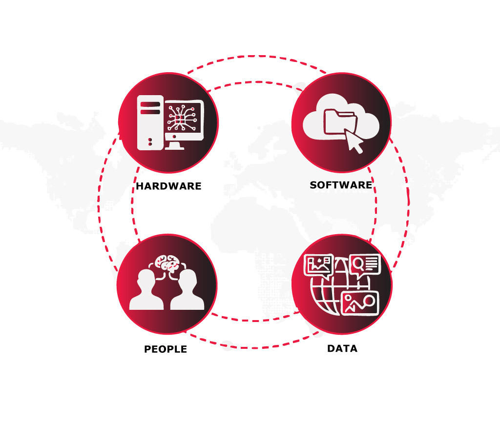
What Are the Four Main Systems of GIS?
The Short Answer: Hardware, Software, Data and People
Together, these systems enable geographic information to be captured, analysed, managed, and visualised in a meaningful way.
02 Feb 2026 | 4 min read
The four main systems of GIS are hardware, software, data, and people.
While GIS is often associated with mapping software, it is better understood as a broader system made up of interconnected components. Each plays a distinct role, and GIS only works effectively when all four systems operate together.
Understanding this framework is essential for anyone studying or working with spatial information, including planners, architects, engineers, and environmental professionals.
Each of the four systems plays a specific role within a GIS. We’ll start with hardware, which provides the physical foundation for all GIS operations.
1. Hardware
Hardware refers to the physical equipment required to run a GIS. This includes computers, servers, mobile devices, GPS units, scanners, and other tools used to collect, store, and process spatial data.
At a basic level, hardware provides the computing power needed to manage large datasets and perform spatial analysis. More complex GIS workflows, such as 3D modelling or high-resolution spatial analysis, often require more advanced hardware with greater processing capability and storage.
Hardware also plays a role in how geographic data is captured. Field devices such as GPS receivers, tablets, drones, and sensors allow spatial information to be collected directly from the physical environment and brought into a GIS for analysis.
Without appropriate hardware, even the most advanced GIS software cannot function effectively. Hardware forms the foundation that enables all other GIS systems to operate.
2. Software
Software refers to the programs and applications that allow geographic data to be stored, analysed, and visualised within a GIS. This includes desktop GIS platforms, web-based mapping tools, spatial databases, and analytical software used to work with geographic information.
At a basic level, GIS software provides the tools needed to view maps, manage spatial datasets, and perform common analyses such as querying, measuring, and overlaying data. More advanced software enables complex modelling, spatial statistics, and 3D visualisation.
GIS software also plays a critical role in how data is processed and interpreted. It allows raw geographic data to be transformed into usable information through analysis, visualisation, and mapping outputs that support decision making.
Without appropriate software, GIS data cannot be effectively analysed or communicated. Software acts as the interface between hardware, data, and users, enabling the GIS to function as a practical analytical system.
3. Data
Data refers to the geographic information upon which a GIS is built. This includes spatial data, such as maps, coordinates, and boundaries, as well as attribute data that describes features, such as land use, population, or environmental characteristics.
At a basic level, GIS data provides the raw inputs needed for mapping and analysis. This data can come from many sources, including surveys, satellite imagery, aerial photography, sensors, and existing databases.
The quality of GIS outputs depends heavily on the quality of the data used. Accurate, up-to-date, and well-structured data is essential for reliable analysis and meaningful results. Poor data quality can lead to incorrect conclusions, regardless of how advanced the hardware or software may be.
Data forms the informational core of a GIS. Without reliable geographic data, the system cannot produce useful insights or support effective decision-making.
4. People
People are the users and decision makers who design, operate, interpret, and apply GIS. This includes GIS specialists, analysts, planners, engineers, and other professionals who use geographic information as part of their work.
At a basic level, people are responsible for collecting data, selecting appropriate tools, and carrying out analysis. More importantly, they provide the expertise needed to interpret results, apply context, and make informed decisions based on GIS outputs.
People also play a key role in defining objectives and workflows. The effectiveness of a GIS depends not just on technology, but on how well it is aligned with real-world problems and organisational goals.
Ultimately, people are what give GIS its value. Hardware, software, and data provide the technical capability, but it is human expertise and judgement that turn geographic information into meaningful insight.
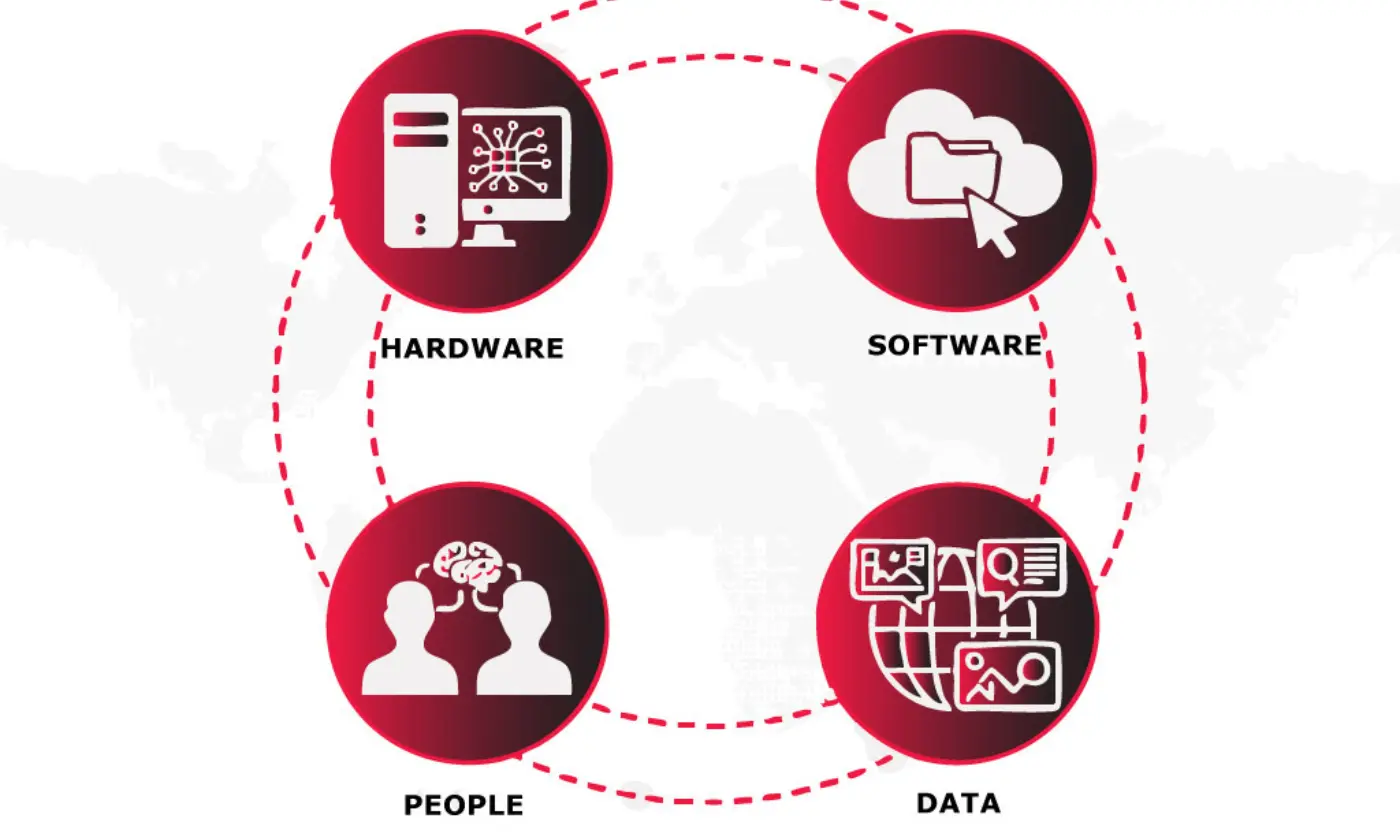
How the Four Systems Work Together
A GIS only functions effectively when hardware, software, data, and people operate as an integrated system. Each component supports the others, and weaknesses in one area can limit the performance of the entire system.
Hardware provides the physical capability to run GIS tools, while software enables data to be analysed and visualised. Data supplies the information needed for spatial analysis, and people apply expertise to interpret results and guide decisions. When these systems are aligned, GIS becomes a powerful framework for understanding spatial relationships and supporting informed decision-making.
Viewing GIS as a system rather than a single tool helps clarify its role across planning, design, environmental analysis, and infrastructure projects. It also highlights why successful GIS outcomes depend on both technical capability and human judgement.
Understanding how these four systems work together provides a strong foundation for anyone learning GIS or applying spatial analysis in real-world contexts.