What is GIS? (Geographic Information System)
GIS, or Geographic Information System, turns location-based data into insight. Rather than just showing maps, it helps us ask questions: Where is something?
How is it changing? And what should we do next? This article will unpack the components of GIS, how it functions in practice, and how organisations are using it to make better decisions.
06 Nov 2025 | 4 min read
Why GIS Matters
GIS is fundamental in many fields because it helps us see patterns, relationships, and trends that are otherwise invisible. For example:
- Urban planners use GIS to understand land use, infrastructure networks, and population growth.
- Environmental scientists use it to track ecosystems, model pollution, or assess the impacts of climate change.
- In public health, GIS supports outbreak mapping, health-resource allocation, and environmental risk assessments.
At Eliot Sinclair, we use GIS not just to map things, but to turn spatial data into actionable insight.
Our services under Survey & Spatial integrate GIS with surveying, mapping, asset management, and more.
Understanding GIS
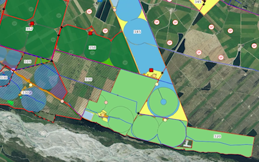
A geographic information system, or GIS, is more than just mapping software; it’s a sophisticated system that integrates hardware, software, and data for capturing, managing, analysing, and displaying all forms of geographically referenced information.
GIS is used to understand spatial relationships, patterns, and trends. GIS technology is applied across diverse fields, from urban planning to environmental science, providing a foundation for mapping and analysis.
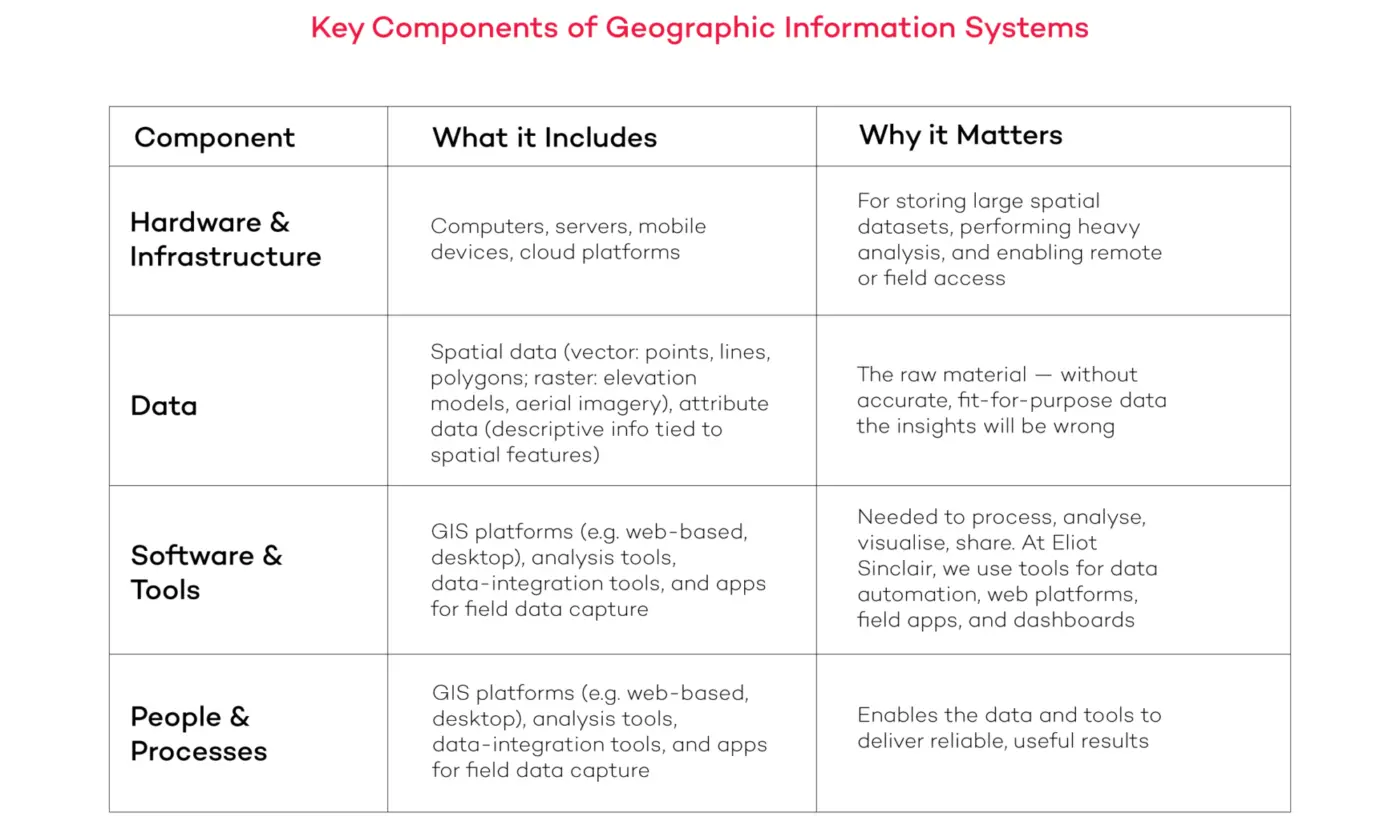
Key Components of Geographic Information Systems
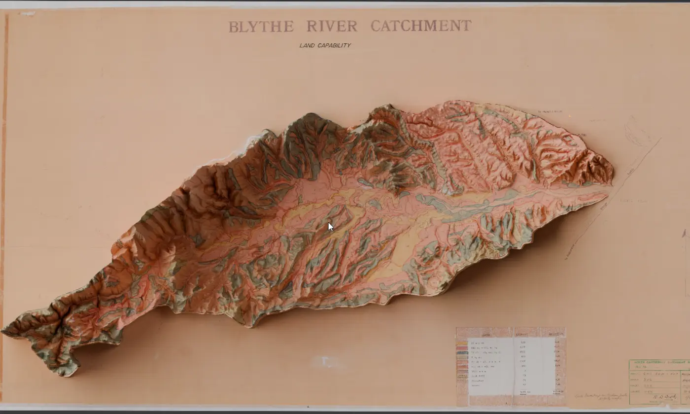
The key components of a geographic information system include hardware (computers, servers), GIS software (like ArcGIS), geographic data, and the people who use the system. Geographic data is further categorised as shown in the table below. These components integrate seamlessly to facilitate spatial analysis and visualisation.
Hardware & Infrastructure
- Computers, servers, mobile devices, cloud platforms.
- For storing large spatial datasets, performing heavy analysis, and enabling remote or field access.
Data
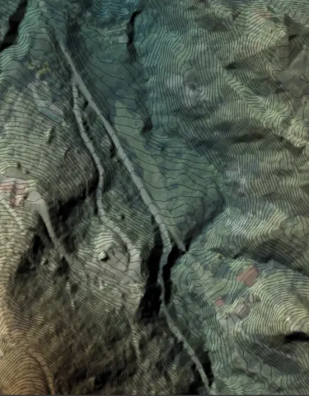
- Spatial data (vector: points, lines, polygons; raster: elevation models, aerial imagery), attribute data (descriptive info tied to spatial features).
- The raw material — without accurate, fit-for-purpose data the insights will be wrong.
Software & Tools
- GIS platforms (e.g. web-based, desktop), analysis tools, data-integration tools, and apps for field data capture.
- Needed to process, analyse, visualise, share. At Eliot Sinclair, we use tools for data automation, web platforms, field apps, and dashboards.
People & Processes
- GIS professionals, surveyors, data managers, planners — plus workflows & quality control.
- Enables the data and tools to deliver reliable, useful results.
Importance of GIS in Modern Technology
GIS technology is applied significantly in modern technology. GIS is used in mapping and data analysis.
The importance of GIS in modern technology stems from its ability to integrate diverse data sets, enabling spatial analysis and providing a foundation for mapping.
GIS helps users understand complex problems. Due to its many uses, GIS provides analysis tools, and enables informed decision-making across various sectors by providing geospatial data and location data.
How GIS Works
Data Collection and Input in GIS
Data collection and input are foundational steps in GIS workflows. Initially, geographic data is gathered from various sources and converted into usable GIS data formats.
This raw data set, comprising both spatial data and attribute data, is then input into the computer system.
GIS software facilitates the conversion of this geographic data into usable GIS data formats.
Spatial Analysis Techniques
Spatial analysis techniques are at the heart of GIS capabilities, enabling users to extract meaningful insights from GIS data.
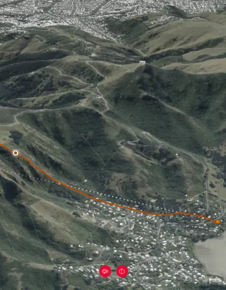
GIS is used to perform operations like buffering, overlay analysis, network analysis, and geostatistical analysis.
These techniques help in understanding spatial relationships, identifying patterns, and modelling real-world phenomena.
GIS can help identify optimal locations, predict future trends, and support informed decision-making.
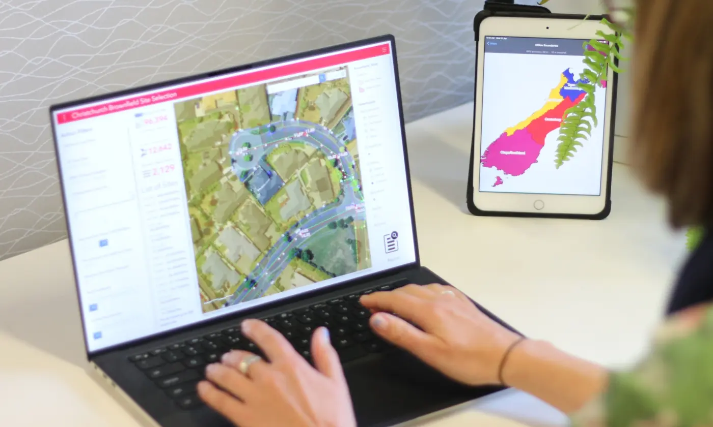
Displaying Information with GIS Software
Visualising information is a crucial output of GIS.
GIS software allows users to create compelling maps and other visual representations of GIS data to communicat
e findings and understand spatial patterns.
This visualisation can include thematic maps, charts, and 3D models. GIS mapping brings clarity to complex data sets, making it easier to communicate findings and understand spatial patterns.
Displaying location data effectively is key to GIS.
Applications of GIS
Using GIS in Urban Planning
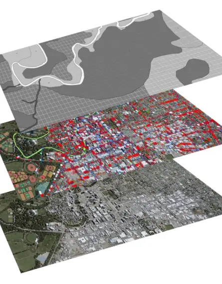
In urban planning, GIS is used extensively to manage and analyse land use, transportation networks, and population density.
GIS supports informed and effective urban development by managing land use, transportation, and population density.
Urban planners use GIS to assess the impact of new developments, optimise infrastructure placement, and create sustainable urban environments.
GIS can help with zoning regulations, emergency response planning, and public service delivery. By integrating diverse data sets, GIS supports more informed and effective urban development.
GIS in Environmental Management
GIS technology is applied significantly in environmental management to monitor ecosystems, track pollution levels, and manage natural resources. GIS aids environmental management by monitoring ecosystems, tracking pollution, and managing natural resources.
Environmental scientists use GIS to analyse habitat suitability, model hydrological processes, and assess the impact of climate change. By overlaying various types of data, such as raster data and vector data, GIS connects data on various environmental factors. GIS analysis provides insights for conservation efforts and sustainable resource management.
Geospatial Data in Public Health
Geospatial data plays a crucial role in public health. GIS informs targeted interventions and public health policies by mapping health-related data sets.
Public health officials use GIS to track disease outbreaks, analyse health disparities, and optimise healthcare resource allocation.
GIS analysis can identify areas with high disease prevalence, assess environmental health risks, and improve access to healthcare services.
By mapping health-related data sets, GIS mapping informs targeted interventions and public health policies. GIS is used to improve public health outcomes.
Popular GIS Software
The future of GIS technology is marked by several exciting trends.
Key trends transforming GIS technology include:
- Cloud-based GIS, offering scalable and accessible GIS capabilities.
- Real-time GIS applications, enabling immediate monitoring and response to dynamic events.
- AI/machine learning integration to automate analysis and improve predictive modelling.
These advancements are transforming how GIS is used across various sectors.
The Role of Geospatial Data in Decision Making
Geospatial data is playing an increasingly critical role in decision-making across various sectors.
GIS analysis is increasingly used by governments, businesses, and organisations to make informed decisions in various sectors.
Governments, businesses, and organisations are leveraging GIS analysis to make more informed decisions related to urban planning, environmental management, public health, and disaster response.
By visualising spatial patterns and trends, GIS can help stakeholders understand complex issues and develop effective strategies.
Innovations in Spatial Analysis
Innovations in spatial analysis are continually expanding the GIS capabilities of GIS technology. Innovations in spatial analysis, such as 3D analysis and geospatial data mining, are expanding GIS capabilities.
Advanced techniques such as 3D spatial analysis, network analysis, and geospatial data mining are enabling more sophisticated insights into real-world phenomena. These innovations are driving advancements in fields like transportation planning, environmental modelling, and risk assessment.
GIS is used to explore the spatial dimensions of complex problems.